
Charlotte Mason had a unique way of presenting a map to children. She used Map Questions before each lesson in their Geography Reader. Unlike typical comprehension questions that quiz a child’s previous knowledge, we Charlotte Mason educators use these questions much like an object lesson in Natural History. By asking methodical questions about a region that will come into that day’s reading, our child directs his gaze and intentionally takes in the features of the land, both its physical and political properties. The map is placed before the child and the teacher asks each question, one at a time, while the student finds the answer on the map.
This Teacher Help has been created to make implementing this crucial practice easier for the busy educator. This resource corresponds to Our Country and Its People by Monroe & Buckbee as well as a few other chapters and books that help round out a three-year course of study for The United States’ Geography. As in our Form IA Map Questions Teacher Help, The Children’s World Atlas (2006 or later including the Expanded U.S. Section) by Colin Arrowsmith has been used, with some additional printable maps linked in the guide for the supplemental resources.
In addition to directions on how to conduct Form 2 map question lessons, a suggested lesson breakdown is provided to help you forecast each term’s lessons. Unlike the Form IA resource, the map questions are compiled by chapter/book rather than by individual lesson. The reason for this being students in Form II are expected to answer the questions again from memory after answering them from the map. Additionally, Charlotte Mason did not require a set number of questions to be answered, unlike in Form IA. Thus, this resource allows for more flexibility to accommodate different students’ pacing and abilities. We have also compiled the questions without their answers into a “Student Book” — this separate file can be used for students to work through the Map Questions independently.
This resource is available as 3) individual years or all three together for an entire program of Form 2 work:
Year 1 covers chapters 1-5 of Our Country and Its People as well as four chapters from Richard Halliburton’s The Book of Marvels: The Occident. (The United States east of the Mississippi)
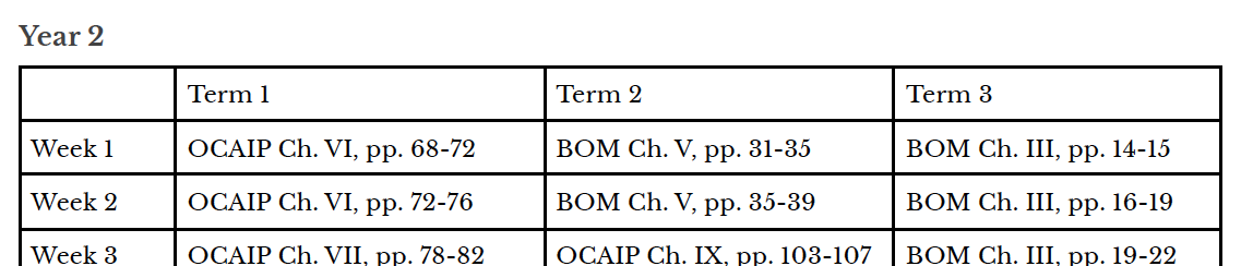
Year 2 covers chapters 6-9 of Our Country and Its People as well as five chapters from Richard Halliburton’s The Book of Marvels: The Occident and a chapter in an online book covering Alaska. (The United States west of the Mississippi and Alaska)
Year 3 covers A Picture Book of Hawaii by Bernadine Bailey (available online) and Far-Flung America by Allan Carpenter (also available online) as well as one chapter from Richard Halliburton’s The Book of Marvels: The Occident. (Hawaii and US holdings in the Caribbean and Pacfic)
*Note: When adding new Form 2 students to your existing Form 2 rotation with an older child(ren), you do not need to begin in Year 1; they can jump in wherever the older students are.
Additional Resources Needed
Each year’s resource includes everything you need to implement your Geography Reader lessons, apart from your text (Our Country and Its People, The Book of Marvels: The Occident, and possibly Far-Flung America which is also available online) and atlas. Specific maps to use are noted in each corresponding lesson. You are welcome to use a different atlas than the one we’ve recommended, but you may have to adjust some of the questions or ask some different ones as all the information may not be included in your atlas. To round out the Geography portion of a Form 2 curriculum, you will need another book (map questions are not required for it) that touches on some other aspect of your country’s geography and maybe coordinates with your time period.
*Note: If you are interested in using these materials with a co-op or group, please email us at contact@adelectableeducation.com for group rates.
Samples: